Ontario's Plain-English Guide to Custom Home Building📞 705-533-1633 | ☎️ 1-866-868-6606 | ✉️ info@icfhome.ca

RTK Positioning on a Home Build: Foundation, Excavation & Grading
Site Work
Excavation
Foundation
Lot Grading
From Site Plan to Foundation: Where RTK Positioning Helps During a Home Build
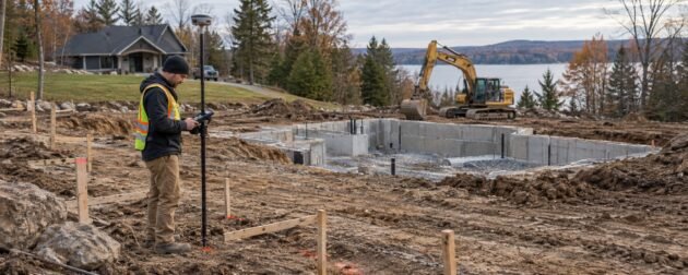
Small positioning errors grow into expensive construction problems quickly, especially once concrete locks an early mistake into the build. A foundation shifted from the approved footprint affects setbacks, framing, and service entries. RTK positioning gives the field crew a repeatable coordinate check while work is still easy to correct.
That is why positioning belongs in the build process before excavation begins, not only at final as-built checks. For crews that want a rover working across changing lots without setting a temporary base each morning, a subscription to RTK correction service for Canada streams NTRIP corrections over 4G LTE or 5G to compatible GNSS equipment. This way, field positions stay tied to the selected reference framework while crews verify critical points against control.
RTK Positioning on a Home Build: How GPS Accuracy Protects Your Excavation, Foundation, and Grading
The short version: RTK GPS lets your crew confirm that the excavation, foundation corners, and lot grading match the approved site plan — in real time, at centimetre-scale accuracy. It does not replace a licensed surveyor for legal boundary work, but it catches expensive mistakes before the concrete is poured.
In this article
- What RTK actually changes about on-site positioning
- Turning the approved site plan into points on the ground
- Checking excavation and foundation location
- Keeping track of elevations during site work
- Where RTK helps with lot grading and drainage
- RTK correction networks vs. setting up your own base station
- Where RTK stops and a licensed surveyor is still required
- What builders should check before depending on RTK
What RTK Actually Changes About On-Site Positioning
Standalone GNSS places a receiver in the right general area, but house construction needs a tighter relationship between the digital plan and the ground. RTK uses carrier phase observations plus correction data from a reference station or network. The rover resolves those corrections in real time and reports a fixed position at centimetre scale.
For a builder, the bigger change is repeatability. The crew returns to the same coordinate during several stages and compares field position with design. That supports layout, excavation, foundation checks, rough grading, and recorded as-built points.
| Site task | What RTK adds | What RTK does not replace |
|---|---|---|
| Building layout | Coordinates tied to the design | Legal establishment of a property boundary |
| Excavation | Repeatable cut and elevation checks | Soil assessment or excavation safety |
| Foundation | Corner and offset verification | Structural dimensions and engineering approval |
| Grading | Fast spot elevations | The approved drainage design |
In Canada, the coordinate frame matters as much as receiver status. Natural Resources Canada defines the Canadian Spatial Reference System as the national framework for latitude, longitude, and height. NAD83(CSRS) is the geometric reference adopted in most jurisdictions, while CGVD2013 is the national height datum. A rover set to the wrong datum or vertical model still returns a precise number — but it is the wrong number for the project.
Turning the Approved Site Plan Into Points on the Ground
Start with control and the reference system
The approved site plan has to enter the field in the same coordinate system used by the rover. Before staking a corner, the crew needs the drawing basis, project units, vertical datum, and site benchmark. Imported CAD or machine files also need to be checked against known geometry.
A sound setup starts with four items:
- Confirm the plan coordinate system and drawing units
- Confirm the benchmark or control point used for elevations
- Load the correct points, lines, or surface into the controller
- Measure at least one known point before setting new points
Stake the geometry that controls the build
Focus on building corners, footing offsets, excavation limits, garage transitions, service entries, and grade breaks. Offset stakes deserve special attention because excavation removes many original marks.
This is especially relevant in Ontario municipalities where building permit applications require a site plan showing the proposed structure’s location relative to lot lines, setbacks, and existing features. RTK gives the crew a fast way to verify that the staked footprint actually matches the approved drawing before a shovel goes in the ground.
Barrie example: The City requires grade plans for infill houses to show proposed and existing elevations, swales, underside-of-footing elevation, top-of-foundation elevation, and finished-floor levels. RTK gives the construction crew a fast way to compare field work with that approved geometry during excavation and foundation work. Required professional surveys and certifications remain separate.
Checking Excavation and Foundation Location
Excavation is the first stage where a position error becomes expensive. RTK lets the crew confirm that the cut is centred on the planned house, that excavation leaves room for forms and drainage work, and that the base elevation matches the design.
Use checks at three moments:
- Before excavation: verify building corners and outside offsets
- After bulk excavation: check cut limits and formation elevation
- Before footing or wall concrete: recheck offsets, corners, and key elevations
The third check matters most. A straight footing form shifted from its intended location still creates a problem. RTK provides an independent coordinate check before the pour, while tape measurements confirm dimensions and diagonals. The two methods support each other.
A foundation placed outside the approved setbacks is not just an engineering problem — it can trigger a stop-work order and force expensive remediation before the municipality will continue inspections. Understanding Ontario’s building rules around setbacks and lot coverage before excavation starts is the best way to avoid that outcome.
Planning a custom home build in Georgian Bay or Simcoe County?
Talk to the team at ICFHome.ca about site work, foundation, and the full build. 45+ years of Ontario construction experience.
Keeping Track of Elevations During Site Work
Horizontal position gets most of the attention, but vertical control drives excavation depth, top of footing, foundation wall height, slab preparation, driveway transitions, and final grade.
GNSS receivers natively measure ellipsoidal height. Construction drawings generally use orthometric elevations tied to a vertical datum or project benchmark. The field controller therefore needs the correct geoid model or site transformation. NRCan identifies CGVD2013 as Canada’s current national height reference and provides tools for converting GNSS heights into orthometric elevations.
For each critical check, record the point name, solution status, antenna height, coordinate system, and measured value. This documentation matters if a discrepancy surfaces later during inspections.
Ontario inspection tip: Ontario inspectors check that your foundation elevation, finished floor level, and lot grading match the approved drawings. Discrepancies at inspection are easier to resolve when you have field records showing what was measured, when, and against which datum. See our guide on Ontario Building Code requirements for 2026 for what inspectors are looking for at each stage.
Where RTK Helps With Lot Grading and Drainage
Grading ties the foundation, garage, driveway, swales, and neighbouring elevations into one surface. RTK speeds up spot checks and shows cut and fill when the design surface is loaded.
For Ontario projects, the approval process is municipal, so the field crew needs the approved grading plan rather than a generic slope rule. Our overview of Ontario lot grading and drainage requirements explains how proposed elevations, swales, finished grade, and final certification fit together. RTK supports that plan by showing where the ground sits relative to specified elevations during construction.
Useful checks during grading include:
- Top of foundation against proposed finished grade
- Swale high and low points before landscaping hides the subgrade
- Driveway and garage transitions before granular material is finalized
- Rear and side yard spot elevations before topsoil placement
The distinction is simple: RTK measures where the ground is. The approved grading design decides where the ground needs to be. The two work together — RTK is the tool that closes the gap between them.
RTK Correction Networks vs. Setting Up Your Own Base Station
Network RTK
With network RTK, the rover connects to an NTRIP caster through mobile data, sends its approximate position, and receives RTCM correction messages. The service handles reference station infrastructure, station coordinates, and data distribution. A crew moves from lot to lot with one rover rather than transporting a temporary base. The field requirements are compatible NTRIP equipment, service coverage, mobile data, and a verified FIX solution.
Your own base station
A local base puts the reference receiver under the contractor’s control. The crew needs a stable location, trustworthy coordinates, power, security, and a radio or internet path to the rover. If the base coordinate is wrong, every rover point inherits that error.
| Question | Network RTK | Own base station |
|---|---|---|
| Daily setup | Log in and verify FIX | Set and initialize the base |
| Infrastructure | Managed by provider | Managed by project team |
| Data link | Cellular internet | Radio or local internet |
| Best fit | Crews moving across covered sites | Remote sites with weak cellular service |
| Main risk | Wrong project settings | Wrong or unstable base setup |
Network RTK reduces hardware and setup work, while a local base gives direct control over the reference source. Both still require verified project control.
Where RTK Stops and a Licensed Surveyor Is Still Required
RTK is a positioning method, not a licence to establish legal boundaries. Ontario’s Surveyors Act defines cadastral surveying to include measuring land to determine, locate, define, establish or re-establish a boundary. The Act restricts that work to licensed practitioners, or staff acting under their direction and supervision.
That boundary matters during a home build. A builder uses RTK for construction layout when the design and control come from authorized project information. The builder should not use a rover to decide where an uncertain property line belongs, recreate a missing legal corner, or resolve a boundary conflict.
Where a municipality or contract requires certification by an Ontario Land Surveyor or another named professional, builder measurements do not replace that responsibility. RTK improves field control — it does not change who is legally authorized to certify specific work.
Before starting any build, confirm which surveys and certifications your municipality requires at each stage. This is part of the broader Ontario building permit process that trips up many first-time custom home builders.
What Builders Should Check Before Depending on RTK
RTK performs well when the whole positioning chain is correct. A green FIX indicator is only one part of that chain. Receiver setup, corrections, coordinate settings, antenna height, and field verification deserve the same attention.
Before production work starts:
- Confirm correction coverage, mobile data, and clear sky view at the actual lot
- Confirm the rover accepts NTRIP and the supplied correction format
- Confirm the project datum, projection, units, and vertical model
- Require RTK FIX for critical layout — reject FLOAT for foundation control
- Check a known point at the start and after any loss of initialization
- Save measured points and field notes so layout decisions remain traceable
These checks matter because NTRIP connectivity alone does not establish a reliable position. The receiver still needs usable satellite geometry, a correct correction stream, and project settings that match the design data.
Builders get the best value from RTK when they treat it as a control system across the build, not a one-time staking tool. The same rover checks the footprint, excavation, footing offsets, wall location, rough grades, and final surfaces, exposing discrepancies early. RTK delivers speed only after the reference system, control, and verification process are right. That discipline keeps field decisions tied to verified geometry and reliable control.
Building in Georgian Bay or Simcoe County?
ICFHome.ca manages the full build — site work, foundation, framing, and keys. Book a call with Harvey to talk through your project.