Ontario's Plain-English Guide to Custom Home Building📞 705-533-1633 | ☎️ 1-866-868-6606 | ✉️ info@icfhome.ca

Conservation Authority Approvals in Ontario: A Simple Guide
Section 28 approvals
Floodplains & wetlands
Homeowner-friendly
Conservation Authority Approvals in Ontario: A Simple Guide (Section 28, 2026)
If you are building near a river, creek, wetland, shoreline, valley slope, or any place where water likes to misbehave, there is a good chance someone will say: “You need Conservation Authority approval.” This guide explains what that actually means in Ontario, why people get stuck, and how to get through it without turning your inbox into a horror movie. The short version: if your lot falls in a regulated area, you need permission from the Conservation Authority on top of your municipal building permit – and the file moves fast only when it arrives complete. We have built across Simcoe County and Georgian Bay – plenty of it near water – for 45 years.
The TL;DR on Conservation Authority approvals
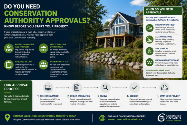
Conservation Authorities (CAs) do not exist to stop your project for sport. Their job is to manage natural hazards – flooding, erosion, unstable slopes, dynamic beaches – and to protect wetlands and watercourses in regulated areas. If your property falls in a regulated area and you are doing certain activities, you may need a permission (often called a “Section 28 permit”) before your municipality can issue a building permit.
The two-key reality: many waterfront and valley projects need both a municipal approval (zoning + building permit) and CA permission. Homeowners get frustrated when they treat those as one approval. They are not. The municipality has one key, the CA has the other – and in a regulated area you need both.
First: what a Conservation Authority is (and what it isn’t)
A Conservation Authority is a watershed-based public agency in Ontario. “Watershed-based” is a fancy way of saying they follow the water, not the municipal boundary line. That is why two lots on the same road can have totally different rules – because one lot drains to a creek and the other drains to your neighbour’s sump pump.
Here is the important part: a CA usually is not your building department and it is not your planning department. Your municipality handles zoning, building permits, and inspections. The Conservation Authority handles specific regulated activities in regulated areas related to hazards and certain features like wetlands and watercourses. Two different offices, two different jobs.
Building near water? Two ways to get through it clean
Do it yourself with the step-by-step PDF, or hand us the lot and we will sort the package – municipal permit and the parallel Conservation Authority permission together.
Done for you – both keys, one team
We coordinate the permit and the CA file
One team handling the municipal permit and the Section 28 permission in parallel.
We pull the regulated-area mapping, tell you which studies your proposal actually needs, line up the survey, grading, and erosion-control package, and run the CA permission alongside the building permit so the two keys arrive together – not six weeks apart. Anywhere in Ontario near water or slopes.
- We confirm the CA jurisdiction and the regulated-area mapping first
- One coordinated set – site plan, grades, setbacks, erosion controls
- We tell you which studies you need before you spend on the wrong one
- 45 years building near Georgian Bay water and valley lots
Free quote, no obligation.
A real person gets back to you within one business day
Do it yourself
The Ontario Building Permit Bible
Your permit, done yourself – without the guesswork.
$10,000$29.99one-time
Everything a builder does to coordinate a permit – including the parallel approvals like Conservation Authority that catch homeowners off guard – in one plain-English playbook.
- How to spot a regulated area before you buy, not after you close
- The complete-submission checklist, so the file does not bounce
- Who to hire to draw it and which studies the CA will want
- How to never fail an inspection – and the mistakes that cost the most
30-day money-back guarantee.
Get instant access – $29.99 →
Secure checkout – download in 2 minutes – yours forever
A Code question tangled up with your CA file?
Setbacks, foundations near a slope, floodproofing details – some of it is Building Code, some is CA. Ask our OBC Code Navigator your exact question – the first two are free, and you can grab the OBC PDF there too.
What triggers “CA approvals” in Ontario
Most homeowner CA approvals fall under the Conservation Authorities Act “Section 28” framework. The short version: certain activities are prohibited in regulated areas unless you get permission. Ontario now has a province-wide regulation that sets the core rules for prohibited activities, exemptions, and permits. In plain English, the activities that commonly trigger CA involvement are:
- Development in a regulated area – building, additions, structures, sometimes pools and decks, depending on location and definition.
- Interference with a wetland – even “small” changes can be a big deal in wetland world.
- Alteration to a watercourse or shoreline – straightening, diverting, culverts, bank work, shoreline stabilization, and the like.
And the regulated area commonly includes floodplains, erosion hazard areas, river and stream valleys, unstable slopes, certain shorelines (Great Lakes and many inland lakes), wetlands, and the lands around them. In other words: if water can move there, has moved there, or wants to move there, it is probably on someone’s map.
Regulated area maps: why your lot “looks safe” but still needs approval
Homeowners often say, “But the lot is high and dry.” Great. That might still be inside a regulated area, because regulated areas are based on mapped hazards and features – not just today’s weather. Floodplains are about the big events. Erosion hazards are about long-term slope stability. Wetlands do not care if it is a sunny day when you take the listing photos.
Most CAs provide regulated-area mapping tools, and many municipalities will flag CA involvement during permit intake. But here is the problem: buyers often discover this after they close, because real estate listings do not come with a free hydrologist. The classic scenario: you buy a beautiful lot near a creek, call the municipality about a building permit, and they say “you will need Conservation Authority clearance first.” You say “but the creek is way over there.” They say “yes.” You have a tape measure; they have a hazard map. The map wins.
What the CA is actually checking (the real checklist)
When a CA reviews a permission application, they are generally trying to confirm your proposal will not create negative impacts related to hazards and regulated features. Here is the builder-friendly version of what they care about:
Flooding
Will the proposed work be safe during a flood, and not make flooding worse somewhere else?
Erosion & slope stability
Are you building too close to an eroding bank or an unstable slope?
Dynamic beaches & shorelines
Will shoreline work mess with natural processes or create new hazards?
Wetlands & watercourses
Are you interfering with a wetland or altering a watercourse, and if so, can it be done safely and appropriately?
If your proposal can demonstrate those things, permissions are often straightforward. If it cannot, the CA may require changes, conditions, or in some cases refuse. That is where projects stall – and where homeowners feel the CA is “being difficult,” even though the file is actually just missing proof.
The approval process in Ontario (what it actually looks like)
Every CA has its own checklists and workflows, but the skeleton is usually similar:
Figure out if you’re regulated
Confirm your property is inside (or near) a regulated area, and what activity you are proposing.
Pre-consultation / screening
Many CAs will do a pre-screen or advise what studies are needed before you formally apply.
Prepare drawings + studies
Site plan, grading, erosion controls, and any required technical reports.
Submit application + fee
Submit the full package. Incomplete packages are the number-one cause of delay.
Completeness check
The CA confirms whether the application is “complete” – this is the detail that controls your timeline.
Review, decision, conditions
The CA issues a permission with conditions, requests revisions, or refuses.
The most important timeline rule: the clock usually starts when the application is complete – not when you send “some drawings.” If your file is missing required information it goes on hold, and that is not the CA being mean. It is the CA saying it cannot responsibly approve until it has the technical proof. Want speed? Aim for a complete submission the first time.
Not sure if your lot is regulated? Have us check before you spend.
The most expensive CA mistake is finding out about it after you have paid for final drawings. We will confirm which Conservation Authority covers your watershed, pull the regulated-area mapping, and tell you the likely studies your proposal needs – so you budget for the right ones and design the home to fit the lot’s water story. Quick paid consult: we scope it on a call and send a secure payment link, so you only pay once you know what you are getting.
What you may be asked to provide (and why)
Homeowners are often shocked by the list of required documents. But most items have a purpose: they prove your project will not worsen hazards or harm regulated features. Depending on the site and the proposal, a CA may ask for some of these:
- Topographic survey or detailed site plan – existing grades, features, setbacks to hazards, and where the work goes.
- Grading and drainage plan – especially important near floodplains and slopes.
- Erosion and sediment control plan for construction – silt fencing, stabilized entrance, and so on.
- Geotechnical report – for slope stability, unstable soils, or foundations near hazards.
- Hydrology / hydraulic analysis – if flooding impacts need to be assessed.
- Wetland or environmental studies – if wetlands or shoreline features are involved.
Yes, it can feel like a lot. But compare it to the alternative: building in a hazard area without understanding the risk. That is how people end up with a gorgeous new home and a seasonal indoor swimming pool – not the fun kind.
Why people struggle with Conservation Authority approvals
When homeowners tell me “the Conservation Authority is impossible,” it is usually one of these:
They discovered the CA too late
Learn about CA permissions after you have paid for final drawings and you may be forced into a redesign – a bigger setback from a bank, different grading, a different driveway location. It feels like the goalposts moved. Really, you started playing before you read the rules.
They assumed “small work” doesn’t matter
Fill, re-grading, retaining walls, shoreline “tidying,” and culverts can all change how water moves – which is exactly why CAs exist. “It’s just a little fill” is not a magic phrase that makes regulation disappear.
They didn’t budget for studies
Technical studies cost money. Skip planning for them and the CA feels like it “added extra costs.” The real fix is budgeting for due diligence when you buy the lot, especially near water or slopes.
They submitted an incomplete package
This is the big one. Missing elevations, missing grades, unclear drawings, or outdated plans are what drag files out. CAs cannot approve vibes – they approve evidence.
They expected the CA to design the solution
CA staff can tell you what they need to see. They generally will not design your grading plan, your slope stabilization, or your stormwater strategy – that is your designer/engineer’s job. Show up with “what should I do?” and you get guidance. Show up with “here is my proposal and here is why it is safe” and you move faster.
Don’t want to coordinate a survey, a geotech, and a CA file yourself? We’ll draw the set.
We design the permit-ready set with the grading, setbacks, and erosion controls the CA wants, line up the survey and any studies, and pre-check the package before you file – for anything from a waterfront home to an addition near a slope. One coordinated team is the single biggest thing that keeps a regulated-lot file moving.
How to make CA approvals simpler (a homeowner playbook)
Here is the process I recommend when someone wants a “simple guide” that actually works on real Ontario projects:
Do this, in order
- Confirm which CA covers your watershed
- Check regulated-area mapping (floodplain, wetland, valley, shoreline)
- Request a pre-consultation / property screening early
- Bring a rough concept (house location, driveway, grading idea)
- Ask what studies are required for your specific proposal
Then build it into the plan
- Build those study requirements into your design scope and budget
- Prepare a clean site plan with grades and setbacks – no “approx”
- Include erosion & sediment controls in the submission
- Submit once you are complete (complete beats fast)
- Respond to comments quickly and completely – one good resubmission
Builder advice: follow that order and your odds of a smooth file go way up. Not perfect – just civilized. Two pages worth bookmarking first: how to read your Ontario survey and the “is this lot buildable?” checklist.
Questions to ask at your first CA conversation
If you want to sound like someone who has done this before (without actually having to suffer first), ask these:
- Is the proposed work in a regulated area, and which hazard or feature is driving it – flooding, erosion, wetland, shoreline, or watercourse?
- What is the minimum safe or required setback from the feature or hazard?
- Do you need a topo survey, grading plan, geotech, or hydrology study for this proposal?
- Is this likely considered minor or major, and what are your service standards once the application is complete?
- Are there common conditions you apply – erosion controls, construction timing, vegetation protection?
Those questions keep the conversation factual. They also stop you from falling into the classic trap of arguing with the existence of water.
“My municipality says I need CA clearance” – what that means
Municipal building departments often will not issue a building permit until they have confirmation that CA requirements are satisfied, when applicable. That does not mean the CA is “taking over” your building permit. It means the municipality is managing risk and following the process: hazard-related permissions first, then the building permit. The CA is not checking your kitchen layout – it is checking whether your site work will be safe and will not create impacts. For the bigger picture on how the pieces fit, see how to get a building permit in Ontario and how long a permit really takes.
What about hearings, appeals, or “escalation”?
Most files never get dramatic. They get approved with conditions once the technical pieces are in place. But if you hit a wall – especially around timelines – some CAs describe an administrative review process when decisions are not made within the required timeframe. The right move is usually to stay professional, document everything, and ask what the next step is under their process.
That said: if your proposal truly increases flood risk, destabilizes a slope, or interferes with a wetland in a way that cannot be supported, a refusal is possible. The “solution” in those cases is usually a redesign – setback, elevation, grading, or a different location – not louder emails.
Costs: what to budget for (without pretending there’s one number)
There are two cost buckets to expect, and the pain almost always comes from surprise, not the number itself:
- CA application fees – these vary by Conservation Authority and by application type and complexity.
- Technical work – survey, engineering, geotech, hydrology, and design time to produce the drawings and reports that prove safety.
If you buy near water or a valley, budget for extra due diligence from day one and you will feel a lot less ambushed. Roll it into your overall numbers with the full cost of building and your lot prep with the land development cost calculator so nothing lands as a spring surprise.
Final reality check: treat CA requirements like a design input
Homeowners who succeed with Conservation Authority approvals do one thing differently: they treat CA requirements like a design factor, not a nuisance. Once you accept that your lot has a water story – flood, slope, wetland, or shoreline – you design the home and the site to fit that story. That is not red tape. That is long-term safety and durability.
And if you are wondering why the CA cares about your little project: water does not stop at your lot line. The whole watershed is connected. Change how water moves on your property and it can change how water behaves on your neighbour’s. CAs are there to keep that from becoming a community-wide headache. So do not wait for the building-permit stage to discover Conservation Authority approvals – start early, get a clear list of required studies, and submit a complete package. You will save time, money, and a surprising amount of mental health.
Related permit guides on this site
Conservation Authority approvals: frequently asked questions
Do I need Conservation Authority approval to build in Ontario?
Only if your property is in a regulated area and you are doing a regulated activity. Regulated areas commonly include floodplains, erosion and slope hazards, valleys, certain shorelines, wetlands, and the lands around them. If you are in one, activities like building, adding fill, re-grading, or altering a watercourse or shoreline can require a Section 28 permission before your municipality will issue the building permit. If your lot is nowhere near water or a slope, you usually will not deal with a CA at all. The safe move is to confirm the regulated-area mapping early – ideally before you buy.
What is a Section 28 permit?
It is the permission a Conservation Authority grants under the Conservation Authorities Act for development and certain activities in a regulated area. Ontario now has a province-wide regulation setting the core rules for what is prohibited, what is exempt, and how permits work. In practice it is a separate approval from your municipal building permit – the CA is confirming your work will be safe with respect to flooding, erosion, and slope stability, and will not harm wetlands or watercourses. You can need both a Section 28 permission and a building permit on the same project.
How do I know if my lot is in a regulated area?
Check the regulated-area mapping for the Conservation Authority that covers your watershed – most publish online mapping tools – and ask the CA directly during a pre-consultation. Your municipality will often flag CA involvement at permit intake too. Do not rely on how the lot looks: a high-and-dry lot can still sit inside a mapped floodplain or erosion hazard, because the maps are based on big-event modelling and long-term slope behaviour, not today’s weather. The best time to confirm this is before you close on the property, not after.
How long do Conservation Authority approvals take?
It varies by CA and by application type, and many publish service standards – how quickly they will tell you the application is complete, and how quickly they will decide once it is. The key detail is that the clock usually starts when your file is judged complete, not when you first send drawings. Minor files move faster than major ones. An incomplete package goes on hold until you supply the missing studies or details, which is the most common reason a file drags on. Submit complete the first time and you avoid most of the delay.
Why does the CA need a survey, grading plan, or geotechnical report?
Because those documents are the proof that your project will not worsen a hazard. A topographic survey and grading plan show where the work sits relative to the floodplain or slope and how water will drain. An erosion and sediment control plan keeps the construction phase from washing soil into a watercourse. A geotechnical report addresses slope stability and foundations near hazards, and a hydrology study assesses flood impacts. You will not need all of them on every project – the CA tells you which ones your specific proposal requires, ideally at the pre-consultation stage.
Does adding fill, a retaining wall, or shoreline work need approval?
Often, yes – more often than people expect. Fill, re-grading, retaining walls, culverts, and shoreline “tidying” can all change how water moves, which is exactly what a Conservation Authority regulates in a regulated area. The work can feel small, but the downstream consequence can be large, so “it is just a little fill” does not exempt it. If you are in or near a regulated area, check with the CA before you move earth or touch a bank or shoreline. Doing unpermitted work in a regulated area can lead to orders to restore the site at your own cost.
Can a Conservation Authority refuse my project?
Yes, though most files are approved with conditions once the technical pieces are in place. A refusal usually happens when a proposal genuinely increases flood risk, destabilizes a slope, or interferes with a wetland in a way that cannot be supported. The fix in those cases is almost always a redesign – a larger setback, a higher elevation, different grading, or a different building location – rather than appeals and arguments. If you hit a timeline wall, some CAs describe an administrative review process; the productive move is to stay professional, document everything, and ask what the next step is.
Note: general guidance, not a ruling on your project. Regulated areas, required studies, fees, and service standards vary by Conservation Authority and by site. Confirm with the CA that covers your watershed – or have us pull the mapping and scope it for you.
Latest posts
Fresh guides, calculators & real-world advice
More from BuildersOntario – scroll to explore.
Loading latest posts…
Tip: shift + mousewheel works great